

DNREC Menu
The DNREC Shoreline and Waterway Management Section uses a data-based method to prioritize statewide dredging projects in Delaware’s Inland Bays and along the Delaware Bay coast.
Shoreline and Waterway Management Section
302-608-5500
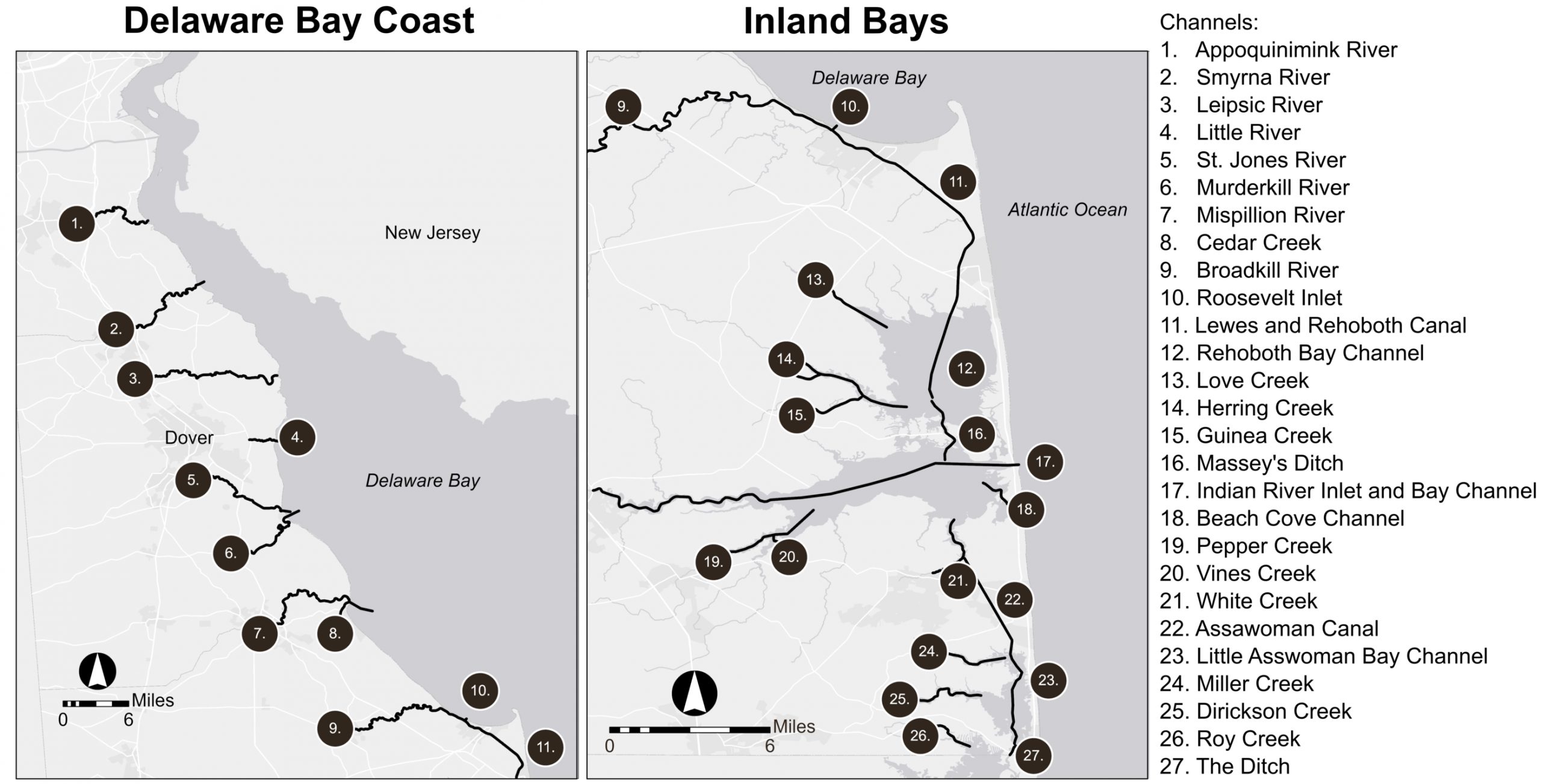
The Shoreline and Waterway Management Section is responsible for waterway management in 27 navigable channels in Delaware, with assistance from federal government partners in some channels.
Certain navigable channels in Delaware, for example the Delaware River Main Channel, C&D Canal, and Wilmington Harbor, are large-scale federal projects maintained by the U.S. Army Corps of Engineers Philadelphia District.
Ten channels — Indian River Inlet and Bay Channel, Massey’s Ditch, the Lewes-Rehoboth Canal, Roosevelt Inlet, Broadkill River, Murderkill River, Mispillion River, Cedar Creek, Little River, and Leipsic River — are federally-authorized.
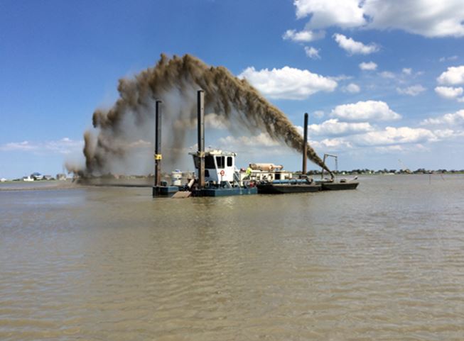
Maintenance performed by the state on federally authorized channels, such as the 2020 Massey’s Ditch project, is coordinated with the U.S. Army Corps of Engineers and U.S. Coast Guard.
Prioritization is an annual process. Data are updated periodically. A list of ongoing and upcoming dredging projects is available on the Waterway Management webpage.
The Section uses the following data to prioritize dredging projects:
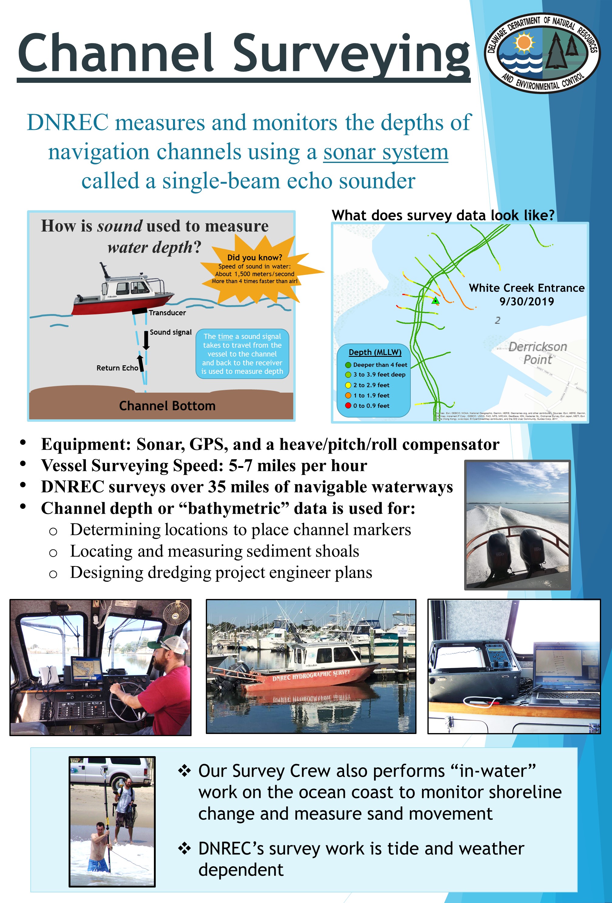
In 2019, the DNREC Shoreline and Waterway Management Section and a contractor surveyed the depth of all 17 Inland Bays channels and five waterways along the Delaware Bay coast. The section generated repeatable survey plans for all 27 channels.
The data collected provides a baseline condition of navigability, identifies areas of shoaling and helps to determine and plan how much sediment might need to be removed from channels.
Continued, periodic depth surveying helps the section monitor hot spots for sediment shoaling in the waterways. The surveys also help determine placement locations for channel markers.
Many channels provide passage from one body of water to another. The dredging prioritization survey shows that considering these channels a dredging priority is of high importance to users.
Channels connecting major bodies of water include Assawoman Canal, The Ditch, Indian River Inlet and Bay Channel, the Lewes-Rehoboth Canal, Little Assawoman Bay Channel, Massey’s Ditch, Rehoboth Bay Channel, White Creek, Roosevelt Inlet, the Murderkill Entrance Channel and the Mispillion River Entrance Channel.
Keeping channels open and safe is a function of DNREC’s Shoreline and Waterway Management Section and was ranked as a factor that should be considered when prioritizing dredging. To enhance understanding of hazards and safety concerns in the Bays, the section monitors boat grounding report locations with the help of local boat towing companies and DNREC Fish and Wildlife Natural Resources Police. These data will help inform locations where increased depth monitoring and potential dredging should occur.
The section must consider a wide range of factors when planning a dredging project, including those related to feasibility and economics. These are some of the most important factors to ensure we remain focused on DNREC’s Vision and Mission and to ensure long term sustainability and success of our Waterway Management Program.
An important part of each project is locating an area for dredged sediment disposal. Due to increased development in the Inland Bays region, the number of upland sediment disposal sites has decreased. In response, the section and regional partners are exploring creative options for sediment disposal including beneficial use of dredged sediment.
Beneficial use projects might include using the sediment for beach nourishment, as used for the 2020 Massey’s Ditch project, or wetland restoration, as planned for the 2022 White Creek project.
There are environmental windows for dredging projects in Delaware’s waterways meant to protect sensitive habitats and species from the impacts of dredging. Typically, dredging can only occur in the Inland Bays from October to March.
Each project must obtain a State Subaqueous Lands and Water Quality Permit, a U.S. Army Corps of Engineers Permit, and a Federal Consistency Determination from the Delaware Coastal Management Program.
DNREC’s Division of Fish and Wildlife periodically updates maps of public boat ramp and marina facilities. This helps inform dredging project decisions for improving waterway access in Delaware.
The cost of a project must also be considered. Project cost can vary based on the amount of sediment that needs to be removed, sediment type, scheduling considerations, disposal method and the distance to a disposal site.
From June to November of 2019, the section used online and in-person surveys to gather public input on the navigability of Delaware’s Inland Bays. The survey was available online and was shared at three public open houses in fall of 2019 at locations in and around the Inland Bays.
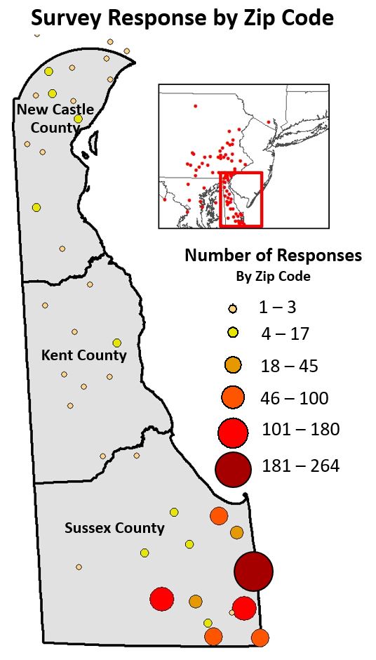
The survey received more than 1,000 responses, the majority from residents of Sussex County and the Inland Bays area. The survey responses provide valuable information that will help guide the planning and prioritization of dredging projects in Delaware’s Inland Bays.
The dredging prioritization survey was available between June and November of 2019. It received 1,033 responses from 83 different ZIP codes in five states. While the survey reached a wide geographic extent, nearly 90% of surveys completed were from residents of Sussex County, Delaware.
More than 500 survey participants reported that they boat on Indian River Inlet and Bay Channel, indicating that this is one of the most heavily used channels in the Inland Bays. Over 400 participants responded that they boat on Assawoman Canal, Little Assawoman Bay Channel, Massey’s Ditch and Rehoboth Bay Channel.
Motor boating was reported as the most popular activity in the Inland Bays among survey participants, followed by fishing, crabbing, kayaking, sailing, having a waterway-based business and clamming.
Survey participants ranked three criteria highly for prioritizing dredging projects in Delaware:
Related Topics: boating, channel, dredge, dredging, inland bays, watershed stewardship, waterways
Delaware's Governor
State Agencies
Elected Officials
General Assembly
Delaware Courts
State Employees
Cities & Towns
Delaware State Code
State Regulations
Business First Steps
Phone Directory
Locations Directory
Public Meetings
Voting & Elections
Transparency
Health Insurance
Tax Center
Personal Income Tax
Privacy Policy
Weather & Travel
Contact Us
Corporations
Franchise Tax
Gross Receipts Tax
Withholding Tax
Delaware Topics
Help Center
Mobile Apps
E-mail / Text Alerts
Social Media

Built by the Government Information Center
©MMXXIV Delaware.gov