

DNREC Menu
Homeowners’ insurance does not cover flood damage. Flood insurance is available through the National Flood Insurance Program.
Kathy Potter
302-608-5500
FEMA’s National Flood Insurance Program (NFIP) has introduced a new flood insurance risk rating method. The goal of Risk Rating 2.0 is to provide fair flood insurance rates using industry best practices and cutting-edge technology. It delivers easier-to-understand rates that better reflect the flood risk for each property.
Learn more on FEMAs Risk Rating 2.0: Equity in Action web page and the NFIP’s Delaware State Profile fact sheet.
The National Flood Insurance Program (NFIP) is administered by the Federal Emergency Management Agency (FEMA) which identifies and maps areas that are subject to flooding under certain conditions, establishes minimum criteria for development in identified flood prone areas, and underwrites flood insurance coverage.
FEMA works, partially through the NFIP, to reduce future flood damage and to break the cycle of repetitive flood damage by encouraging communities to adopt and enforce floodplain management regulations and by providing affordable insurance to property owners, renters, and businesses.
FEMA uses Flood Insurance Rate Maps (FIRMs) to delineate low, moderate, and high flood risk areas and to establish where the mandatory flood insurance purchase requirement applies. States, counties, and communities can use FIRMs to manage flood risk. These maps can also be used for activities like planning development and zoning decisions, informing property owners of flood risk and planning flood hazard mitigation projects.
FEMA’s Flood Smart website provides information about flood insurance including how to purchase a policy, the cost of flooding, and how to prepare for a flood.
An elevation certificate is a document that lists a building’s location, lowest point of elevation, flood zone and other characteristics. It can be completed by a licensed land surveyor, architect or engineer and is used to enforce local building ordinances and to help determine flood insurance rates.
Elevation certificate requirements for a proposed project should be verified with your local floodplain administrator.
Helpful FEMA Publications
Resources for Local Officials
Resources for Real Estate Professionals
FEMA provides options to request changes and amendments to federal Flood Insurance Rate Maps (FIRMs).
A Letter of Map Change (LOMC) is a letter issued by FEMA which reflects an official change to an effective FIRM. LOMCs are issued in response to a request to FEMA to revise or amend its effective flood map to remove a property or reflect changed flooding conditions on the effective map.
There are various types of LOMC.
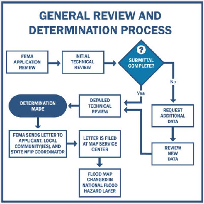
A Letter of Map Amendment (LOMA) is issued when the scale of the FIRM does not allow for small areas of natural high ground to be shown outside the Special Flood Hazard Area (SFHA).
A Conditional Letter of Map Amendment (CLOMA) is a letter from FEMA stating that a proposed structure that is not to be elevated by fill (natural grade) would not be inundated by the base flood if built as proposed.
A Letter of Map Revision based on Fill (LOMR-F) is similar to a LOMA, but instead of being based on natural ground elevations, the property or structure has been elevated by fill above the base flood elevation.
A Conditional Letter of Map Revision-Fill (CLOMR-F) is a letter from FEMA stating that a parcel of land or proposed structure that will be elevated by fill would not be inundated by the base flood if fill is placed on the parcel as proposed or the structure is built as proposed.
A Letter of Map Revision (LOMR) is an official revision to an effective FIRM that may change flood insurance risk zones, floodplain and/or floodway boundary delineations, planimetric features, and/or base flood elevation.
A Conditional Letter of Map Revision (CLOMR) is a letter from FEMA stating that a proposed project would, upon construction, affect the hydrologic or hydraulic characteristics of a flooding source and thus result in the modification of the existing regulatory floodway, the effective Base Flood Elevation (BFE) or Special Flood Hazard Area (SFHA).
FEMA provides an online option for requesting changes and an online LOMC tutorial more information.
The FEMA eLOMA system allows licensed land surveyors and engineers to submit LOMA applications online.
NFIP Technical Bulletins provide guidance for complying with the NFIP’s building performance requirements. The bulletins help state and local officials interpret the NFIP regulations and are also useful resources for homeowners, insurance agents, building professionals, and designers.
Related Topics: drainage and flooding, flood insurance, flooding, floodplain, Health and Safety, nfip, watershed stewardship
Delaware's Governor
State Agencies
Elected Officials
General Assembly
Delaware Courts
State Employees
Cities & Towns
Delaware State Code
State Regulations
Business First Steps
Phone Directory
Locations Directory
Public Meetings
Voting & Elections
Transparency
Health Insurance
Tax Center
Personal Income Tax
Privacy Policy
Weather & Travel
Contact Us
Corporations
Franchise Tax
Gross Receipts Tax
Withholding Tax
Delaware Topics
Help Center
Mobile Apps
E-mail / Text Alerts
Social Media

Built by the Government Information Center
©MMXXIV Delaware.gov