

DNREC Menu
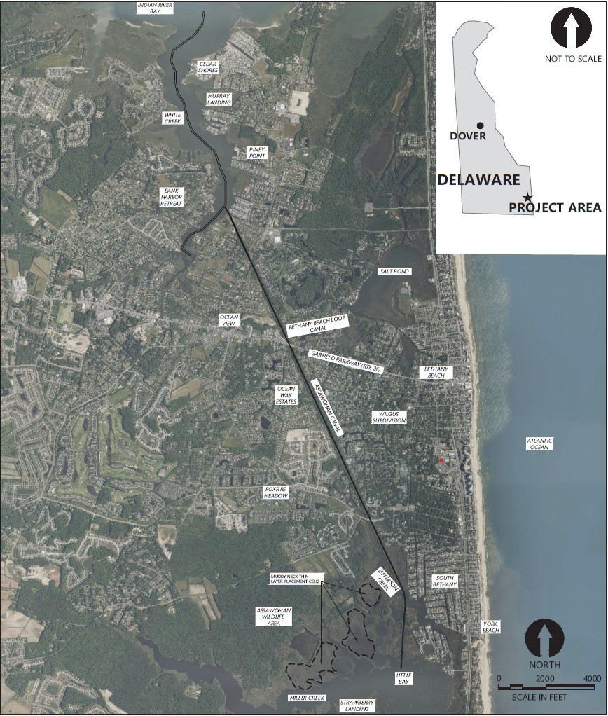
Preparation work for a dredging project in White Creek and the Assawoman Canal began in November, 2023. Both waterways are important navigation channels in the Inland Bays.
White Creek is northwest of Bethany Beach. It flows from the south to the north into Indian River Bay. It serves numerous marinas and boat ramps and connects the Assawoman Canal to the bay.
The White Creek navigation channel was last dredged as part of a phased program from 1997 through 2001. The Assawoman Canal was most recently dredged from 2010 to 2015.
Since then, navigability within both channels has decreased due to sedimentation and shoaling.
Nov. 2023 – Jan. 2024: Tree trimming and the removal of woody and marine debris is complete
Jan. 2024: Assembly of dredge and pipeline is complete.
Feb. 2024: Dredging in the White Creek, completed in early March, 2024
March 2024: Dredging in Assawoman Canal
Updated March. 25, 2024
The Department of Natural Resources and Environmental Control (DNREC) awarded the project to dredge White Creek and the Assawoman Canal to McLean Contracting Company on Oct. 27, 2023. The $8.483 million project began in November of 2023. The portion of White Creek that was not completed during a previous project at the beginning of 2023 was dredged prior to Assawoman Canal.
The initial task was to trim overhanging trees and remove woody debris from Assawoman Canal. This began in November of 2023 and was completed by early January 2024.
Concurrently, pipeline was being staged and fused in Holts Landing State Park. Fused sections of pipe, 500 to 1,000 feet in length, were launched from the boat ramp and towed to White Creek and Assawoman Canal.
By the first full week of February, the dredge was assembled, test pumps were complete and dredging of White Creek began. Dredging in White Creek was complete by March 7, 2024.
Following the completion of White Creek, the dredge repositioned to Assawoman Canal. Dredging started at the confluence with White Creek, at the northern end. The dredge has been running 24 hours a day, 7 days a week, working its way down the canal. It is expected that a Time of Year Restriction extension will be granted, allowing the Canal dredging to be completed this spring.
The project is funded largely from appropriations to DNREC in the fiscal year 2022 and FY23 budgets.
DNREC’s data-based method to prioritize dredging projects identified White Creek and the Assawoman Canal as top priorities. This method includes surveys of residents and users of the waterway. And it considers analysis of channel depth, boater safety and environmental considerations.
The project will improve navigability in White Creek and the Assawoman Canal. It will restore an area of highly degraded coastal salt marsh using dredged material. It will help coastal wetlands adapt to sea level rise and other environmental stressors.
The project will remove approximately 80 thousand cubic yards of shoaled sediments. This will bring the White Creek navigation channel and the Assawoman Canal to previous dredge design depths.
DNREC will make beneficial use of the dredged material to restore wetlands in the Muddy Neck Marsh Complex, which is close to the dredging area. This will restore historically degraded wetlands. And it will improve the resilience of the marsh in future coastal storms.
The project will use thin layer placement of dredged materials. This minimizes marsh disturbance and restores the marsh through natural recolonization of vegetation.
DNREC engaged engineering services from Anchor QEA + Woods Hole Group Joint Venture to design the dredge project and oversee its construction.
For White Creek, an area 60 feet wide and 12,400 feet long will be dredged — from the mouth of the creek, at Indian River Bay, to where the main channel splits into two prongs near Betts Avenue, in Ocean View.
For the Assawoman Canal, an area 35 feet wide and 2,400 feet long had been dredged, between its confluence with White Creek and the Central Avenue bridge, earlier in 2023. The remainder of the Canal will be dredged with a channel width of 35 feet.
The White Creek channel will be restored to a depth of 4 feet below mean lower low water (MLLW). The northern Assawoman Canal will be restored to a depth of 3 feet below MLLW.
| Length (Linear Feet) | Width (Linear Feet) | Depth (MLLW) | Proposed Dredged Material (Cubic Yards) | Actual Dredged Material (Cubic Yards) | |
|---|---|---|---|---|---|
| White Creek – Main Channel | 12,400 | 60 | -4 | 38,200 | 30,515 |
| Assawoman Canal | 20,909 | 35 | -3 | 42,400 | TBD |
| Total | 80,000 | TBD | |||
| Note: The depths do not include an allowed “overdredge” of up to one foot in White Creek. The quantity totals do. There is no allowance for overdredge in Assawoman Canal. | |||||
The project will provide multiple benefits, including:
The Muddy Neck Marsh Complex is part of the Assawoman Wildlife Area. It is an expansive coastal salt marsh system located west of the southern end of the Assawoman Canal. It stretches up to a half mile from the adjacent upland shoreline.
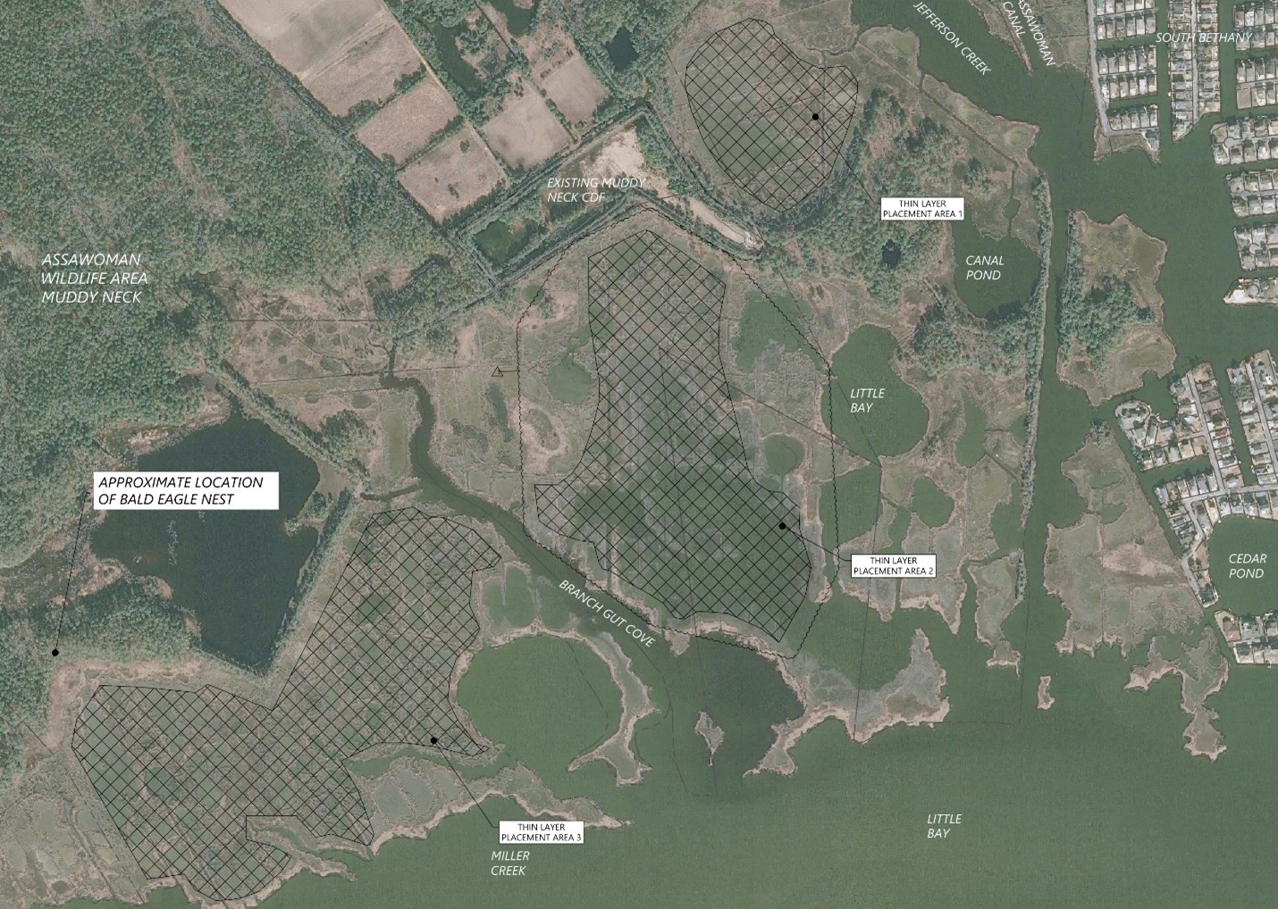
The site is a fragmented tidal wetland complex with several open water pool areas. Plant life in the area includes smooth cordgrass, salt hay cordgrass, spike grass, common reed, glassworts, sea lavender, marsh elder, groundsel bush, salt marsh bulrush and switchgrass.
The Assawoman Wildlife Area supports a variety of fish species, including Atlantic silverside, mummichog, spot, striped killifish, summer flounder and sheepshead minnow.
Restoration of the Muddy Neck Marsh Complex will provide improved habitat value to one of Delaware’s critical natural areas. This area has been subject to ongoing threats of climate change, sea level rise and marsh platform loss.
The Muddy Neck Marsh Complex has experienced widespread ponding and fragmentation over the last 60 to 70 years. Between 2007 and 2017 alone, approximately 11 acres within the Complex changed from vegetated area to open pond. Of the 122 acres proposed for marsh restoration, about 70 acres are unvegetated.
| Area (Acres) |
Max. Volume (Cubic Yards) |
Avg. Placement Thickness (Feet) |
|
|---|---|---|---|
| Cell 1 | 16.1 | 13,200 | 0.5 |
| Cell 2 | 53.4 | 85,000 | 1.0 |
| Cell 3 | 53.5 | 50,000 | 0.6 |
The project will place restoration material on the marsh using thin layer pressure spray nozzles. Materials will be spread over three areas (Beneficial Use Cells) in thicknesses ranging from a half foot to one foot.
The dredged material will be mostly mud (silt and clay) and some sand. This material is not suitable to place on local beaches (as in the 2020 Masseys Ditch Dredging Project). But this material is ideal for restoring degraded local marshes.
Restoring degraded marshes using dredged material is a common practice nationwide and has been done in Delaware. In 2013, DNREC’s Shoreline and Waterway Management Section and Wetlands Monitoring and Assessment Program joined together for a successful marsh restoration at the Piney Point Tract of Assawoman Wildlife Area. That project used a thin layer of material dredged from Pepper Creek.
Numerous projects in southern New Jersey have used dredged material to restore marshes.
Currently, this project is in the construction phase.
Tree trimming and the removal of woody and marine debris from the project area has been completed as well as pipe fusing and pipeline assembly.
Dredging started at the confluence of Assawoman Canal and White Creek. From there dredging up the prongs then down to the mouth of the Creek was completed. Completion of the Assawoman Canal is expected by the end of April 2024.
Permit conditions require the dredging project to be completed by the end of March. A request to allow dredging until the end of April has been made and is expected to be granted.
The project area will be monitored by DNREC through 2028.
For more information, please contact Joseph Faries at 302-900-1546.
Related Topics: assawoman canal, boating, channel, dredge, dredging, inland bays, watershed stewardship, waterways, white creek
Delaware's Governor
State Agencies
Elected Officials
General Assembly
Delaware Courts
State Employees
Cities & Towns
Delaware State Code
State Regulations
Business First Steps
Phone Directory
Locations Directory
Public Meetings
Voting & Elections
Transparency
Health Insurance
Tax Center
Personal Income Tax
Privacy Policy
Weather & Travel
Contact Us
Corporations
Franchise Tax
Gross Receipts Tax
Withholding Tax
Delaware Topics
Help Center
Mobile Apps
E-mail / Text Alerts
Social Media

Built by the Government Information Center
©MMXXIV Delaware.gov